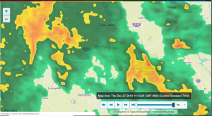
Coming with some timely irony considering Mike Hobson’s article about the “river rats” yesterday, the National Weather Service issued today a flood warning for our area. This comes with thunderstorms likely continuing through early next week. It could get rough. Everyone please stay safe and alert.
RIVER FLOOD WARNING
ISSUED: 1:28 PM DEC. 27, 2018 – NATIONAL WEATHER SERVICE
The National Weather Service in Birmingham AL has issued a

* Flood Warning for
the Cahaba River At Centreville.
* from Friday afternoon to Sunday morning...or until the warning is
cancelled.
* At 12:00 PM Thursday The stage Was 3.3 feet.
* Flood stage is 23 feet.
* Minor flooding is forecast.
* Forecast...rise above flood stage by Friday afternoon and
continue to rise to near 25.9 feet by Saturday morning. The river
will fall below flood stage Saturday evening.
* Impact...At 23 feet...Pasture lands begin to flood in the
Centreville area.
WIND ADVISORY
ISSUED: 2:22 PM DEC. 27, 2018 – NATIONAL WEATHER SERVICE
...WIND ADVISORY REMAINS IN EFFECT UNTIL MIDNIGHT CST TONIGHT...

* TIMING...through this evening.

* WINDS...Sustained 20 to 30 mph, with gusts around 30 to 35 mph.

* IMPACTS...Gusty winds could knock down tree branches and
vulnerable or weakened trees. Travel may be difficult at times
for those in high profile vehicles.

PRECAUTIONARY/PREPAREDNESS ACTIONS...

A Wind Advisory means that wind gusts up to 35 mph may occur.
Winds this strong can make driving difficult...especially for
high profile vehicles. Use extra caution.

&&
FLASH FLOOD WATCH
ISSUED: 2:21 PM DEC. 27, 2018 – NATIONAL WEATHER SERVICE
...FLASH FLOOD WATCH REMAINS IN EFFECT THROUGH FRIDAY AFTERNOON...

The Flash Flood Watch continues for

* Portions of central Alabama, east central Alabama, northeast
Alabama, northwest Alabama, and west central Alabama,
including the following areas, in central Alabama, Autauga,
Bibb, Blount, Chilton, Coosa, Dallas, Elmore, Jefferson,
Lowndes, Montgomery, Perry, Shelby, St. Clair, Talladega, and
Walker. In east central Alabama, Calhoun, Chambers, Clay,
Cleburne, Lee, Macon, Randolph, and Tallapoosa. In northeast
Alabama, Cherokee and Etowah. In northwest Alabama, Marion and
Winston. In west central Alabama, Fayette, Greene, Hale,
Lamar, Marengo, Pickens, Sumter, and Tuscaloosa.

* Through Friday afternoon

* A strong weather system will bring several rounds of rain and
thunderstorms through early Friday. This will result in rainfall
totals of 2 to 3.5 inches with isolated higher amounts.

* Heavy rainfall on already saturated soil will result in
instances of flash flooding. Localized flooding may also occur
in urban, low lying, and poor drainage areas. If you encounter
flooded roadways when driving, Turn Around, Don't Drown.

PRECAUTIONARY/PREPAREDNESS ACTIONS...

A Flash Flood Watch means that conditions may develop that lead
to flash flooding. Flash flooding is a very dangerous situation.

You should monitor later forecasts and be prepared to take action
should Flash Flood Warnings be issued.


